


Mapas (Maps, Annotated) (Spanish Edition)

 4.4 (91 items)
 Limited Time Sale
$26.47 cheaper than the new price!!
Free cash-on-delivery fees for purchases over $99
Product details
| Management number | 232079782 | Release Date | 2026/06/18 | List Price | $17.64 | Model Number | 232079782 | ||
|---|---|---|---|---|---|---|---|---|---|
| Category | |||||||||
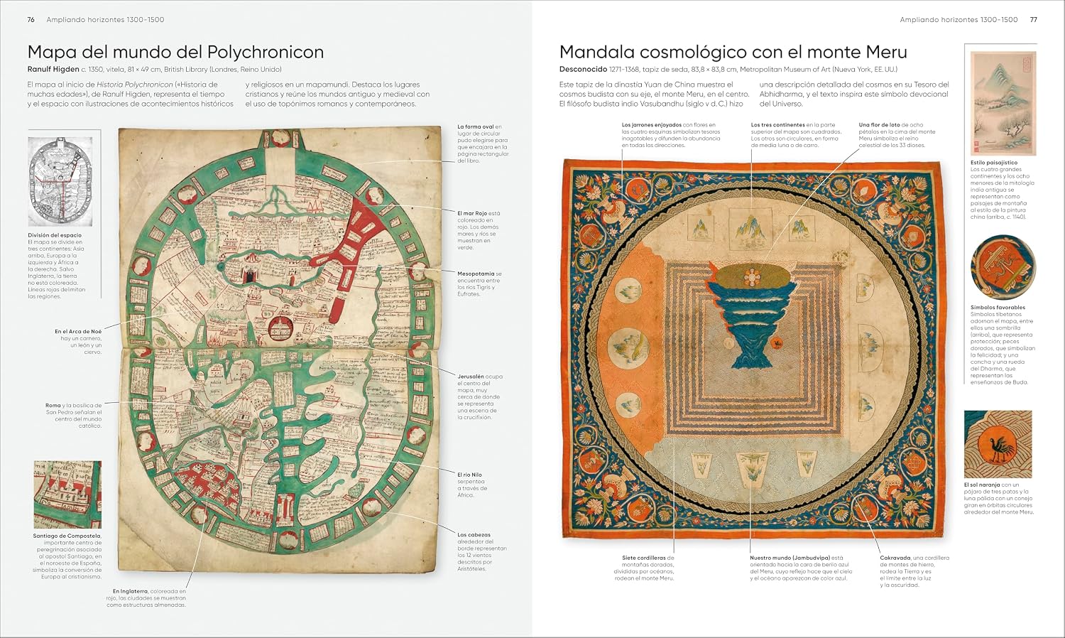
Un recorrido de más de 3000 años de historia a través de los mapas más famosos e importantes del mundo. Descifra los mapas medievales de Mappae Mundi, piérdete en los antiguos mapas estelares chinos, y maravíllate con los intrincados estudios del fondo del océano y la superficie lunar con este libro de mapas.¿Qué hay en su interior?Más de 300 mapas con su contexto cultural e histórico.Explicaciones fáciles de entender sobre las escalas, las brújulas y los símbolos metereológicos para comprender el lenguaje de los mapas.Toda la información sobre las técnicas cartográficas, desde el grabado y la impresión hasta diferentes proyecciones utilizadas a lo largo de la historia.Lleno de información e imágenes, y organizado cronológicamente, este libro de mapas es una increíble recopilación de mapas famosos de todo el mundo, acompañados de anotaciones y análisis detallados a través de los descubrirás las fascinantes historias que esconden. ¡Descubre cómo los navegantes polinesios trazaban sus rutas con palos a través del Pacífico, qué es una línea de rhumb y dónde se decía antiguamente que acechaban los dragones!El regalo perfecto para los amantes de la geología y la historia.___________________________________________________________________This glorious guided tour of cartographic history features more than 300 of the most famous and important maps of all time.Immerse yourself in ancient Chinese star charts, decipher medieval Mappae Mundi, and marvel at intricate surveys of the ocean floor and the lunar surface. Discover how Polynesian navigators used sticks to chart their way across the Pacific, what a rhumb line is, and where dragons were once said to lurk.Organized chronologically, the book includes: The most celebrated examples of the last 3,000 years. It explains everything from scales and compasses to meteorological symbolsTechniques such as engraving, printing, and cartographic projection.Entries that place maps in their wider cultural and historical context, providing a complete overview of the subject.Combining reproductions with precise annotation, visual analysis, and pull-out details, Maps, Annotated brings an expertly curated selection of the world’s most celebrated maps right into your home, telling the fascinating stories behind each one. Read more
| ASIN | B0FNW7JHB7 |
|---|---|
| ISBN13 | 979-8217135424 |
| Language | Spanish |
| Publisher | DK |
| Dimensions | 9.56 x 1.42 x 11.44 inches |
| Item Weight | 5.05 pounds |
| Print length | 480 pages |
| Publication date | May 26, 2026 |
Historic


Contemporary


Correction of product information
If you notice any omissions or errors in the product information on this page, please use the correction request form below.
Correction Request Form